If we’ve learnt anything from the last 12 months, it’s that digital solutions are revolutionising the way we approach our roles. We’ve rapidly adapted to remote working and streamlined how to make the most of technology.
Whilst remote surveying solutions have always been our specialism at TruMetric, we’ve recently seen an increase in the demand for distanced services, with the construction industry fully embracing PropTech.
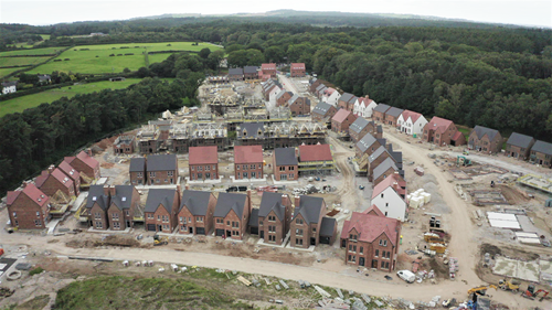
In particular, drone surveys are a reliable, accurate and safe alternative to traditional ground surveys. This surveying method can be utilised for specific buildings or site wide for developments, pre, during and after completion.
Using the latest in UAV (Unmanned Aerial Vehicle) technology, TruMetric can map, photograph and record the built environment, accurately collating data for specific industries such facilities and asset management and building and construction.
In the current climate, safety is key and any methods of reducing contact and maintaining social distancing are enabling us to adapt and utilise new solutions to navigate a lack of onsite contact. As mentioned in our previous PropTech blog, estate agents are a key demographic who are utilising digital capturing. By using high resolution drone surveys, 3D mapping and topographical solutions, they can continue to operate and provide a realistic portfolio of properties despite restrictions.
TruMetric’s drones and qualified drone pilots combine to provide a safe solution to collecting data in the most useful formats. Identifying hazards and controlling risk in construction, all whilst adhering to strict regulations, can be difficult without the right equipment.
Of course, safety is a priority in the construction and development sector, from initial planning stages through to completion and beyond. Commercial drone surveys can provide a valuable alternative to onsite ground surveying methods and negate many associated costs of these traditional methods;
Using a drone reduces the number of people required on site to undertake a traditional ground survey Removes the need for additional access equipment such as ladders, scaffolding, cherry pickers or MEWPs. Surveyors aren’t placed in a position of risk, where traditional methods would see them physically assessing potentially dangerous areas, at height such as roofs. Drone technology provides a unique, detailed vantage point that the human eye can’t replicate Improves the speed of surveying and the accuracy of the data accumulated


